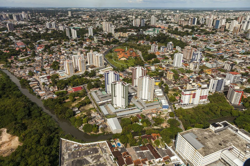
Socio-spatial segregation in Manaus
The emergence of favelas in Manaus dates back to the late 19th century, driven by socio-economic transformations and local changes causing central area overcrowding. Uncontrolled growth led to environmental issues, and public and private land invasions resulted from a housing deficit. Urban planners note government focus on specific regions, leaving peripheral areas more susceptible to invasion and lacking infrastructure. Irregular occupations are linked to economic growth in the 1970s, contributing to social inequality. Manaus faces challenges in water supply, sanitation, deforestation, and electricity distribution, with ongoing urbanization projects and an ecological corridor connecting different regions.
Autoria: Entry translated by ChatGPT, originally published in Portuguese in here[1].
About[editar | editar código-fonte]
The favelas in the city of Manaus began to emerge in the late 19th century, as several socio-economic transformations that Brazil was going through and local changes began to cause overcrowding in the city's central area, forming the first subnormal agglomerates.
In 350 years, Manaus achieved development, but uncontrolled and unplanned growth caused a series of environmental problems in the city. Several areas of Manaus emerged and became neighborhoods after public and private lands were invaded. This historical problem was triggered by the lack of popular housing. The incidence of invasions intensified with the increase in the population due to the migration of people from municipalities in the interior to the capital, as well as migrants who came from other states in search of work and better life opportunities in Manaus, after the industrialization boom. On the other hand, there are also indications of land grabbing, a criminal market for the illegal occupation of land, which, according to the police, may be linked to organized crime.
According to data from the Ministry of Cities, the municipality had a deficit of approximately 68,483 housing units until 2006. This would mean, according to such research, approximately 300,000 citizens without access to formal housing or living in precarious housing. According to IBGE data from 2010, the Cidade de Deus neighborhood has the highest number of favelas, with 10,559 dwellings in deprived areas.
Urban planners and scholars of urban issues in Manaus point to the region between the Solimões and Negro rivers, as well as the Mindu igarapé, as the urban area in which the city government historically acted with greater rigor and planning, and where the government invested the most, and where most neighborhoods with better social indicators are located. This region has lost population and presented an increasingly lower population density, despite being the region of the city with the highest infrastructure and social equipment index. The lower-income populations and criminals thus end up invading the areas on the outskirts of the municipality, which are more deprived of infrastructure. It is worth mentioning, however, that even within the area delimited by these rivers, there are some regions of social exclusion, such as the Ceasa favela, in the Mauazinho neighborhood. On the other hand, there are also some high-income nuclei such as Flores, Parque 10 de Novembro, Cidade Nova, and the Tarumã condominiums, which are located outside the area delimited by these rivers.
But other specialists remember that the area of Avenida Torquato Tapajós was sparsely populated due to the marshy and unhealthy terrain near the end of the urban area. The population built their homes in the neighborhood located above, Santa Etelvina. The occupation of the avenue took place after private real estate investments occurred, consisting of the construction of several condominiums and offices that changed the profile of that region. The Municipal Institute of Urban Planning (Implurb) and the Institute of National Historic and Artistic Heritage (Iphan) signed an agreement aimed at making infrastructure projects viable for Manaus, especially for the revitalization program of the Center of Manaus.
Due to the growing degradation of the city center, some urbanization, requalification, and revitalization projects have been suggested. Neighborhoods located outside the expanded center, such as Japiim, which years ago housed a poor and working population and had little infrastructure, have undergone significant economic change. Today, such neighborhoods have commercial equipment and some infrastructure investment. Other scholars attribute the problems of irregular occupations in the city to the large economic growth that occurred in the 1970s (nicknamed the "economic miracle") and the arrival of thousands of migrants seeking better living conditions.
The water supply in the city is provided by the company Águas de Manaus. The company has been working with the objective of universalizing water supply, as well as expanding access to sanitation, from the current 35% to 80% by 2030. The city also has 36 water and sewage treatment plants, of which 25 are in operation, two are deactivated, and nine are not functioning. About 22% of the urban area of the city is deforested. The distribution of electricity is carried out by the company Amazonas Energia.
The Central-South, North, and East regions are the most encompassed by the city's urbanization. The city government continues to expropriate homes located on the banks of the Mindu stream. The implementation of an Ecological Corridor is also being built in the area, a work that will connect the North and Central-South to the East. Manaus is the only Brazilian city to have an ecological corridor.
In addition to the center-periphery duality that partially explains social inequality in the city, there are also visible areas where contrast is visible and diverse income profile groups coexist, as is the case with neighborhoods such as Cidade Nova, Aleixo, and São José, which have high-income housing complexes located near favela regions.
Ver também[editar | editar código-fonte]
Projetos de Urbanização e reassentamento de favelas - Marcia Bezerra (entrevista)

