The Peripheries Map: mudanças entre as edições
(Criou página com ''''The Peripheries Map''' is an interactive platform that maps and promotes initiatives and public policies aimed at Brazil's peripheral areas. Created in partnership between the National Secretariat of Peripheries and Fiocruz, the project seeks to promote visibility, social justice, and support the formulation of effective policies for these territories '''Authorship''': Information from this entry was reproduced by the Marielle Franco Favelas Dictionary Team, based on...') |
|||
| Linha 52: | Linha 52: | ||
*[[Plano de Enfrentamento da COVID19 e Promoção da Saúde nas Favelas Edital FIOCRUZ]] | *[[Plano de Enfrentamento da COVID19 e Promoção da Saúde nas Favelas Edital FIOCRUZ]] | ||
*[[146x Favela]] | *[[146x Favela]] | ||
*[[Champion of Public Health and Social Justice Richarlls Martins]] | |||
*[[Mapa das Periferias]] | |||
*[[Guilherme Simões]] | *[[Guilherme Simões]] | ||
*[[Richarlls Martins]] | *[[Richarlls Martins]] | ||
Edição das 15h30min de 16 de outubro de 2024
The Peripheries Map is an interactive platform that maps and promotes initiatives and public policies aimed at Brazil's peripheral areas. Created in partnership between the National Secretariat of Peripheries and Fiocruz, the project seeks to promote visibility, social justice, and support the formulation of effective policies for these territories
Authorship: Information from this entry was reproduced by the Marielle Franco Favelas Dictionary Team, based on official networks[1]
About the Map
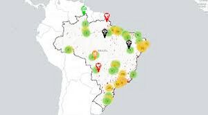
The Peripheries Map is an innovative and interactive platform designed to comprehensively map and promote the realities of Brazilian peripheries. Developed as a geoportal, the Map allows users to search for and locate information about a wide range of initiatives, from Federal Government projects to local innovations created by peripheral communities themselves. The platform also highlights public policies aimed at favelas and other marginalized urban areas.
This initiative results from a strategic collaboration between the National Secretariat of Peripheries and Fiocruz, launched in October 2023, with a planned duration of two years. The Peripheries Map is structured around five key pillars: urbanism, geotechnology, information technology, communication, and mobilization. Each of these pillars was carefully selected to ensure that the platform not only offers visibility to the peripheries but also acts as an essential tool for planning and executing more effective public policies that directly address the specific needs and challenges of these territories.
In addition to its informative role, the Peripheries Map integrates various initiatives into a single digital space, facilitating collaboration and knowledge sharing among the many actors involved in the urban and social development of peripheries. By connecting government and community projects, the platform strengthens dialogue between public and local spheres, contributing to the creation of sustainable and inclusive solutions that respect and value the particularities of each territory.
www.instagram.com/guilhermesperiferias/reel/C89UCW-BoFV
What is the project's objective?
The Peripheries Map aims to provide and produce data for the socioterritorial development of communities; to give visibility to local initiatives already taking place across the country, strengthening the fight for social justice; and to support the formulation of public policies aimed at peripheral territories.
The Peripheries Map has a central mission to produce and make essential data available for the socioterritorial development of Brazil's peripheral communities. The project seeks not only to map and bring visibility to local initiatives already underway across the country but also to strengthen the fight for social justice by recognizing and amplifying the voices and actions of these communities. Additionally, the Peripheries Map aims to support the formulation and implementation of more effective and targeted public policies that address the specific needs of peripheral territories, contributing to the reduction of social and territorial inequalities.
What activities will be developed in the project?
The Peripheries Map involves a series of strategic and collaborative activities to ensure the platform's construction and success.
The main activities include:
- Collaborative Mapping of Peripheral Territories: This process involves the active participation of peripheral communities in identifying and mapping their own territories, promoting an inclusive and participatory approach.
- Consolidation of Concepts, Databases, and Metadata: The project works on clearly defining concepts and creating a robust and reliable database, including metadata that ensures the accuracy and usability of the collected information.
- Community Dialogue and Mobilization: Through ongoing engagement and dialogue activities, the project seeks to mobilize communities to actively participate, ensuring that their perspectives and needs are reflected in the platform.
- Use of Open Technologies: The adoption of free and open technologies is a priority, ensuring that access to information is democratic and that the tools used can be replicated and adapted by other initiatives.
- Adherence to the National Spatial Data Infrastructure (INDE): The project also aligns with INDE, ensuring that geospatial data complies with national standards and norms, facilitating its integration with other government and institutional initiatives.
Project Timeline
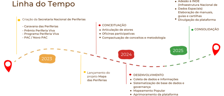
The Peripheries Map project timeline is carefully structured to ensure the effective implementation of its goals and activities:
Outubro de 2023
- Lançamento do projeto e início das atividades de planejamento e engajamento com os parceiros envolvidos.
Primeiro Semestre de 2024
- Início do mapeamento colaborativo, desenvolvimento da base de dados e metadados, e mobilização inicial das comunidades periféricas.
Segundo Semestre de 2024
- Consolidação dos dados coletados, integração das tecnologias livres e alinhamento com a INDE, além da intensificação das atividades de diálogo com as comunidades.
2025
- Finalização da plataforma interativa, com a disponibilização pública do Mapa das Periferias. Início da utilização dos dados e informações para subsidiar políticas públicas e fortalecer as iniciativas locais.
October 2025
- Official project conclusion, with an evaluation of achieved results and planning for future platform expansions and updates.
See also
- Complexos de Favelas
- Lista de Favelas do Rio de Janeiro
- Plano de Enfrentamento da COVID19 e Promoção da Saúde nas Favelas Edital FIOCRUZ
- 146x Favela
- Champion of Public Health and Social Justice Richarlls Martins
- Mapa das Periferias
- Guilherme Simões
- Richarlls Martins


